Take an easy hike to spectacular overlook in Zion National Park with 360-degree views. The image below is a 230-degree crop.

~ Joy of Photography
Take an easy hike to spectacular overlook in Zion National Park with 360-degree views. The image below is a 230-degree crop.
Great Basin National Park in Nevada offers some nice high-altitude hikes. Bristlecone pines live at high elevations where few other trees survive.

Great Basin National Park in Nevada offers some nice high-altitude hikes. The Alpine Lakes trail is one of my favorites.


This is a panoramic image that I took on January 21, 2023. It’s cropped into a 35mm 3×2 frame.
Continue reading “Tips for Dramatic Zion Photography, Kolob Canyon Sunset”

This is a panoramic image that I took on January 20, 2023.
Continue reading “The Art of Panoramic Photography: Tips from Red Cliffs Conservation Area”
The monsoon season, mid-July to mid-August is the best time to visit either the North or South Rim of the Grand canyon. There are frequent afternoon and evening showers with rainbows and lightning.

Continue reading “Capturing Lightning at the Grand Canyon: Tips and Tricks”

Snow Canyon State Park is about 15 minutes from where I live. When big cloud formations build on a day when the air is clear, I like to head to the park at sunset.
Continue reading “Stunning Sunset Views in Snow Canyon State Park”

Snow Canyon State Park is about 15 minutes from where I live. When big cloud formations build on a day when the air is clear, I like to head to the park at sunset.
Continue reading “Top Spots for Sunset Views in Snow Canyon State Park”

This is a view from Alstrom Point overlooking Lake Powell and Glen Canyon. It is from May of 2020. Water levels keep receding, marinas have closed and boat activity is down.
Alstom Point is in Kane County Utah.
Continue reading “Spectacular Sunsets at Glen Canyon Alstrom Point on Lake Powell”
This image is near Quail Creek State Park in Hurricane Utah.

Hurricane, Utah was first settled in 1896, and received its name after a whirlwind blew the top off a buggy in which Erastus Snow was riding. Snow exclaimed, “Well, that was a Hurricane. We’ll name this ‘Hurricane Hill’.”
Hurricane, which is pronounced “Her-ah-kun” by local residents (mimicking the accent of early Liverpudlian settlers), is in eastern Washington County.
Situated on Utah State Route 9, Hurricane lies between Interstate 15 and Zion National Park, and as a result has numerous motels, restaurants and other commercial establishments that serve a portion of the millions of tourists that visit Zion National Park each year.
The above info is from Wikipedia.
Quail Creek State Park and Sand Hollow State Park are minutes away from the spot in which I took this image.
Image Details
Continue reading “How to Capture Car Light Trails at Sunset”

Quail Creek State Park is very close to where we live. It’s a small but popular park for fishing, boating, kayaking, and hiking.
Quail Creek reservoir was completed in 1985 to provide irrigation and culinary water to the St. George area. Most of the water in the reservoir does not come from Quail Creek but is diverted from the Virgin River and transported through a buried pipeline.
Two dams form the reservoir. The main dam is an earth-fill embankment dam. The south dam is a roller compacted concrete dam, constructed to replace the original earth-fill dam that failed in the early hours of New Year’s Day 1989.
The maximum depth of Quail Creek can reach 120 feet, so it is cold enough to sustain the stocked rainbow trout, bullhead catfish, and crappie. Largemouth bass, which is also stocked, and bluegill thrive in the warmer, upper layers of the reservoir.
Image Details
Continue reading “Explore Sunset and Bird Photography at Quail Creek State Park”
Standing In the Creek

Quail Creek State Park is very close to where we live. It’s a small but popular park for fishing, boating, kayaking, and hiking.
Quail Creek reservoir was completed in 1985 to provide irrigation and culinary water to the St. George area. Most of the water in the reservoir does not come from Quail Creek but is diverted from the Virgin River and transported through a buried pipeline.
Two dams form the reservoir. The main dam is an earth-fill embankment dam. The south dam is a roller compacted concrete dam, constructed to replace the original earth-fill dam that failed in the early hours of New Year’s Day 1989.
The maximum depth of Quail Creek can reach 120 feet, so it is cold enough to sustain the stocked rainbow trout, bullhead catfish, and crappie. Largemouth bass, which is also stocked, and bluegill thrive in the warmer, upper layers of the reservoir.
Image Details
Continue reading “Photography Tips for Quail Creek State Park Reflections”
Park Overlook at Sunset

Quail Creek State Park is very close to where we live. It’s a small but popular park for fishing, boating, kayaking, and hiking.
Quail Creek reservoir was completed in 1985 to provide irrigation and culinary water to the St. George area. Most of the water in the reservoir does not come from Quail Creek but is diverted from the Virgin River and transported through a buried pipeline.
Two dams form the reservoir. The main dam is an earth-fill embankment dam. The south dam is a roller compacted concrete dam, constructed to replace the original earth-fill dam that failed in the early hours of New Year’s Day 1989.
The maximum depth of Quail Creek can reach 120 feet, so it is cold enough to sustain the stocked rainbow trout, bullhead catfish, and crappie. Largemouth bass, which is also stocked, and bluegill thrive in the warmer, upper layers of the reservoir.
Image Details
Continue reading “Sunset Photography and Reflection Tips at Quail Creek State Park”
Most of the time Elliot Falls is nothing but a trickle but we got there in early June after a big rain storm. This spot is where Elliot Falls flows into Lake Superior.
Continue reading “My Favorite Pictured Rocks Spot: Elliot Falls at Sunset”
Sleeping Bear Dunes National Lakeshore near Empire, Michigan is a great four-season park and one of my favorite Midwest locations.
My favorite trail is to Sleeping Bear Point. It’s an excellent spot at sunrise and sunset in the summer months.
Continue reading “Sleeping Bear Point: A Top Sunset Spot in Michigan”
Sleeping Bear Dunes National Lakeshore near Empire, Michigan is a great four-season park and one of my favorite Midwest locations.
One of my favorite spots in the park is the trail to Sleeping Bear Point. It’s an excellent sunrise and sunset location in the summer months.

Feature Image Details
Continue reading “Sleeping Bear Dunes National Lakeshore Best Sunset Spot”
Due to the direction of the canyon walls, Bryce Canyon generally presents more opportunities at sunrise than sunset.
The Bryce Point Overlook provides a genuine Sunset opportunity. These images were taken at sunset on the same day.

Continue reading “Bryce Point is the Best Sunset Location in Bryce Canyon”

Feature Image Details
This is a panorama composite of 12 vertical images taken with a Canon 16-35MM F4 L Lens.
In my previous post I showed a “Green River Overlook”. It is the same “Green River” but a completely different overlook.
This one you can drive right up to with no problem, get out of your car, walk a short distance and take pictures.
But you do need dramatic light, clouds, clear air, and good technique.
I merged 12 different images into that panorama. The right hand side of the image was the most difficult part. Contrast between the sun and the sky was intense. 6 of the 12 images contained various exposures of the sun.
Here is my panorama split into three equal parts.
Continue reading “Stunning Green River Overlook: Canyonlands Sunset Panorama”

Murphy Point is a 3.6-mile round trip hike with excellent views off the western end of the Island in the Sky. The trail is downhill most of the way with only 150 feet of elevation to contend with.
I started hiking with with clouds brewing and they kept getting darker and darker. When I got to the overlook, I looked around and found a small ledge I could duck under if needed.
Winds soon started howling at perhaps 40 miles per hour and would have blown a sturdy tripod with a my camera on on it had I not held on to it.
It started raining and sleeting so I ducked under the ledge I found. Sand was blowing all around like mad. Sand got into my camera and tripod despite the shelter and despite me attempting to shield them from the wind.
The wind, rain, and sleet lasted about 5-10 minutes. Then it became dead calm again.
I came out from the shelter announcing “there should be a rainbow”. And there was, right in front of me.
Plan the Shot
Just be at Murphy Point at sunset. Good luck with the clouds, light, and rainbow.
I was at the visitor center about two hours earlier and asked the ranger if he could deliver a rainbow for me that evening.
Feature Image Details
These clouds were exceptionally low, discounting fog, the lowest I have ever seen.
This was a a simple shot.
I emerged from the shelter and started shooting with a fairly standard range zoom.
I used a Canon 24-105MM F4 L Lens at 60mm, F16, for 1/4 second at ISO 200.
My general lens of choice for most landscape photography is the Canon 16-35MM F4 L Lens.
Rainbow Math
To find the apex of the rainbow, look 180 degrees from the sun. In this shot, there is no apex. just a very low end of a bow due to the low clouds.
At noon, in the summer, the rainbow will be beneath the horizon unless you are up in a plane or a high elevation looking down. From a plane, you might actually see a full circle, especially at sunrise or sunset.
On a double rainbow, the colors are inverted. Note that red is on the left in one rainbow and the right on the other.
The primary rainbow is on the inside. A secondary rainbow, on the outside, is caused by the light being reflected twice on the inside of the droplet before leaving it.
A secondary rainbow appears about 10° outside of the primary rainbow, with inverse order of colors.
Memory Trick
Roy G Biv
The colors are always in this order, one way or the other: Red, Orange, Yellow, Green, Blue, Indigo, Violet
More Rainbow Details
Wikipedia has more Rainbow Details including this interesting tidbit.
A spectrum obtained using a glass prism and a point source is a continuum of wavelengths without bands. The number of colours that the human eye is able to distinguish in a spectrum is in the order of 100. Accordingly, the Munsell colour system (a 20th-century system for numerically describing colours, based on equal steps for human visual perception) distinguishes 100 hues. The apparent discreteness of main colours is an artefact of human perception and the exact number of main colours is a somewhat arbitrary choice.
Newton, who admitted his eyes were not very critical in distinguishing colours, originally (1672) divided the spectrum into five main colours: red, yellow, green, blue and violet. Later he included orange and indigo, giving seven main colours by analogy to the number of notes in a musical scale. Newton chose to divide the visible spectrum into seven colours out of a belief derived from the beliefs of the ancient Greek sophists, who thought there was a connection between the colours, the musical notes, the known objects in the Solar System, and the days of the week. Scholars have noted that what Newton regarded at the time as “blue” would today be regarded as cyan, and what Newton called “indigo” would today be considered blue.
Hmmm.
Roy G Cbv is not that easy to remember.
There are many other interesting facts in the above link.
Other Canyonlands Images
Both Mesa Arch and Murphy Point are easy trails.
Note. This post is conceptually the other end of the rainbow in the second link above.
It is much wider as lighting conditions changed. The right portion vanished.
Nearby
If you are at the Canyonlands Island in the Sky district, then Arches National Park is nearby.
For most, it’s probably the reverse, visiting Arches then going to Canyonlands as a side trip.
Arches National Park Images
Equipment List
Those interested in my equipment and recommendations can find it here: Mish’s Equipment List.
Please Subscribe: Click to Subscribe by Email.
If you like this article, please share by email or use one of the share buttons beneath the article.
More Canyonlands National Park images coming up.
Please Subscribe and Follow.
Thanks!
Mike “Mish” Shedlock

Murphy Point is a 3.6-mile round trip hike with excellent views off the western end of the Island in the Sky. The trail is downhill most of the way with only 150 feet of elevation to contend with.
I hiked in with clouds brewing but wanted to get to the end by sunset. Winds all the way but the clouds kept getting darker and darker.
I looked around and found a small ledge I could duck under if needed.
I needed.
Winds soon started howling at perhaps 40 miles per hour and would have blown a sturdy tripod with a my camera on on it had I not held on to it.
It started raining and sleeting so I ducked under the ledge I found. Sand was blowing all around like mad. Sand got into my camera and tripod despite the shelter and despite me attempting to shield them from the wind.
The wind, rain, and sleet lasted about 5-10 minutes. Then it became dead calm again.
I came out from the shelter announcing “there should be a rainbow”. And there was, right in front of me.
Plan the Shot
Just be at Murphy Point at sunset. Good luck with the clouds, light, and rainbow.
I was at the visitor center about two hours earlier and asked the ranger if he could deliver a rainbow for me that evening.
Feature Image Details
This was a a simple shot.
I emerged from the shelter and started shooting with a fairly standard range zoom.
I used a Canon 24-105MM F4 L Lens at 29mm, F16, for 1/6 second at ISO 200.
My general lens of choice for most landscape photography is the Canon 16-35MM F4 L Lens.
At 29mm I could have used either lens. I went with the one on my camera given the sand that was all over everything.
Nearby
If you are at the Canyonlands Island in the Sky district, the Arches national Park is nearby.
For most, it’s probably the reverse, visiting Arches then going to Canyonlands as a side trip.
Also see Canyonlands National Park: Mesa Arch Sunrise
Both Mesa Arch and Murphy Point are easy trails.
Arches National Park Images
Equipment List
Those interested in my equipment and recommendations can find it here: Mish’s Equipment List.
Please Subscribe: Click to Subscribe by Email.
If you like this article, please share by email or use one of the share buttons beneath the article.
More Canyonlands National Park images coming up.
Please Subscribe and Follow.
Thanks!
Mike “Mish” Shedlock

Arches national Park is a red-rock wonderland in Southern Utah. The park has over 2,000 natural stone arches, in addition to hundreds of soaring pinnacles, massive fins and giant balanced rocks.
Double Arch is in the very popular Windows section of the park.
All the literature that I have read suggests one cannot get a “sunset” image from this location.
But there it is. Double Arch at Sunset.
OK but …
Yes, the sun is not in the image.
However, the best sunset images look away from the sun.
Feature Image Details
This is not an easy shot. It is a blend of 8 images of varying exposures some for the inside of the arch, and some for the clouds.
I also used a Canon 11-24 F4.0 L lens at 11mm, not exactly a routine piece of equipment.
But equipment is not the point of this article.
Thinking contrary to popular opinion is.
Two Tips
If possible, I go for both, but choose the one that makes the most sense.
Well over half the time, it makes no sense at all to shoot towards the sun at sunset.
Yet, I constantly observe people shooting in the wrong direction.
Arches National Park Images
Equipment List
Those interested in my equipment and recommendations can find it here: Mish’s Equipment List.
Please Subscribe: Click to Subscribe by Email.
If you like this article, please share by email or use one of the share buttons beneath the article.
More Arches images coming up.
Please Subscribe and Follow.
Thanks!
Mike “Mish” Shedlock

The hike to Delicate Arch is a 3.1 round trip hike with a 480 foot climb. It’s rated moderate.
The hike is very popular and you will almost never have the place to yourself.
If your mission is to have a great hike you cannot go wrong in any kind of reasonable weather. But if your goal is to get a great image, things are more difficult. You need good light with good clouds. You need to be at the top about an hour before sunset.
The arch is in a shadow of mountains at sunset starting mid-April.
I took this panorama on April 13. You can see the shadows closing in to the right and in the foreground up to the base of the arch.
Feature Image Details
I took 8 images, overlapped heavily, and stitched then together in Lightroom.
I used a Canon 16-35MM F4 L Lens at 28 mm, F16, for 1/13 of a second.
The Featured image is significantly cropped. Here is the full panorama.

Pano Tip
It’s far easier to cut out what you do not want than add what you didn’t capture.
Since you are combining images, you will end up with a huge number of pixels even when the final result is cropped.
I frequently take vertical images to make what looks like a horizontal image.
Arches National Park Images
Equipment List
Those interested in my equipment and recommendations can find it here: Mish’s Equipment List.
Please Subscribe: Click to Subscribe by Email.
If you like this article, please share by email or use one of the share buttons beneath the article.
More Arches images coming up.
Please Subscribe and Follow.
Thanks!
Mike “Mish” Shedlock
This is what a Shell Gas Station looked like in the late 1920s.

The Bodie State Historic Park is a genuine California gold-mining ghost town.
Visitors can walk down the deserted streets of a town that once had a population of nearly 10,000 people. The town is named for Waterman S. Body (William Bodey), who had discovered small amounts of gold in hills north of Mono Lake. In 1875, a mine cave-in revealed pay dirt, which led to purchase of the mine by the Standard Company in 1877. People flocked to Bodie and transformed it from a town of a few dozen to a boomtown.
Only a small part of the town survives, preserved in a state of “arrested decay.” Interiors remain as they were left and stocked with goods. Designated as a National Historic Site and a State Historic Park in 1962, the remains of Bodie are being preserved in a state of “arrested decay”. Today this once thriving mining camp is visited by tourists, howling winds and an occasional ghost.
Access
In the winter, you may need a snowmobile to get in. The road is not plowed.
The only access at sunrise, sunset, and the interiors of the building is by permit.
The tour gave us access at sunrise, sunset, and the interiors of the building at mid-day.
Additional Bodie Images – Wide Angle and Tilt-Shift Discussion
Those articles discuss the importance of very wide angle lenses and tilt-shift lenses for photographing Bodie and the interiors of buildings in general.
Eastern Sierra Area
Equipment List
Those interested in my equipment and recommendations can find it here: Mish’s Equipment List.
Please Subscribe: Click to Subscribe by Email.
If you like this article, please share by email or use one of the share buttons beneath the article.
This is just the beginning of my Bodie series.
There is much more coming up: Sam Leon’s saloon, the morgue, the Methodist church, a Shell gas station, the schoolhouse, the barbershop, other buildings, and milky way shots at night.
Please Subscribe and Follow.
Thanks!
Mike “Mish” Shedlock

The Bodie State Historic Park is a genuine California gold-mining ghost town.
Visitors can walk down the deserted streets of a town that once had a population of nearly 10,000 people. The town is named for Waterman S. Body (William Bodey), who had discovered small amounts of gold in hills north of Mono Lake. In 1875, a mine cave-in revealed pay dirt, which led to purchase of the mine by the Standard Company in 1877. People flocked to Bodie and transformed it from a town of a few dozen to a boomtown.
Only a small part of the town survives, preserved in a state of “arrested decay.” Interiors remain as they were left and stocked with goods. Designated as a National Historic Site and a State Historic Park in 1962, the remains of Bodie are being preserved in a state of “arrested decay”. Today this once thriving mining camp is visited by tourists, howling winds and an occasional ghost.
Access
In the winter, you may need a snowmobile to get in. The road is not plowed.
The only access at sunrise, sunset, and the interiors of the building is by permit. The cost is steep. My wife Liz and I went on a photography tour at $800 a pop.
The tour gave us access at sunrise, sunset, and the interiors of the building at mid-day.
I was not that interested in instruction. Rather, I paid for access.
These tours are worth it, especially if you need tips and guidance.
Feature Image Details
I used Canon EOS 5D Mark IV camera coupled with a Canon TS-E 17mm f/4L Tilt-Shift Lens. This is a straight-up image.
We got lucky. There were very nice clouds at sunset. Then in the evening, for night photography, there were no clouds at all, just what we wanted.
Photography Notes
You get the idea: wide angle.
Eastern Sierra Area
Equipment List
Those interested in my equipment and recommendations can find it here: Mish’s Equipment List.
Please Subscribe: Click to Subscribe by Email.
If you like this article, please share by email or use one of the share buttons beneath the article.
This is just the beginning of my Bodie series. Much more coming up.
Please Subscribe and Follow.
Thanks!
Mike “Mish” Shedlock

Mono Lake is a large, shallow saline soda lake in Mono County, California, in the Eastern Sierras. The lake formed at least 760,000 years ago as a terminal lake in an endorheic basin. The lack of an outlet causes high levels of salts to accumulate in the lake. These salts also make the lake water alkaline.
Mono Lake has two major islands, Negit Island and Paoha Island, plus numerous minor outcroppings. Among the most iconic features of Mono Lake are the columns of limestone that tower over the water surface. These limestone towers consist primarily of calcium carbonate minerals such as calcite (CaCO3). This type of limestone rock is referred to as tufa, which is a term used for limestone that forms in low to moderate temperatures.
This desert lake has an unusually productive ecosystem based on brine shrimp that thrive in its waters, and provides critical habitat for two million annual migratory birds that feed on the shrimp and alkali flies. Historically, the native Kutzadika’a people derived nutrition from the Ephydra hians pupae, which live in the shallow waters around the edge of the lake.
When the city of Los Angeles diverted water from the freshwater streams flowing into the lake, it lowered the lake level, which imperiled the migratory birds. The Mono Lake Committee formed in response and won a legal battle that forced Los Angeles to partially replenish the lake level.
Tufa Types
The tufa types vary interchangeably both between individual tufa towers but also within individual tufa towers. There can be multiple transitions between tufa morphologies within a single tufa tower.
The above is pieced together from Wikipedia.
Feature Image Details
The feature image is a panorama composite of five overlapping images stitched together shortly after sunset.
I used a Canon 16-35MM F4 L Lens at 17mm, ISO 100, for 3.2 seconds at F16 with a circular polarizer to increase the shutter time.
The polarizer was a purposeful error that took hours to correct in Lightroom and Photoshop. I should have used neutral density filters, and I have several, but I did not have them with me that evening. After considerable effort with Lightroom adjustments, I was able to get the look I wanted. The 3.2-second exposure did smoothe out the water as I wanted.
Polarizers have an uneven effect on blue skies and stitching multiple images together compounds the problem significantly.
Polarizer Tips
People misuse polarizers. I generally do not use them on sunny days, especially if I have a lot of sky in the image. Why? The polarizer will darken the sky in a very non-uniform manner that is hard to correct even in Photoshop. I used them on this occasion as a last resort.
I often use polarizers on cloudy days and did so on these images. Here are more images from the glen.
Additional Images Before Sunset


The interesting thing about the above image is the Godbeams are in the opposite direction of the sun. You can verify my statement judging from the bright light hitting the distant background. Prior to this, I had only ever seen Godbeams looking towards the sun.
These Godbeams are actually called Anticrepuscular Rays. Looking towards the sun, they are called crepuscular rays.
There were two other photographers at this location before I arrived. It severely limited my composition choices. For the above image, one photographer agreed to move long enough for me to grab that shot.
I could not get as much foreground in the feature shot as I wanted because another photographer was in the way most of the time.
Be first!
All of these images were taken within a 20-minute or so window.
Equipment List
Those interested in my equipment and recommendations can find it here: Mish’s Equipment List.
Please Subscribe: Click to Subscribe by Email.
If you like this article, please share by email or use one of the share buttons beneath the article.
You can also follow me on Twitter! I have both an economic forum and a photography forum.
MishMoments is a subset of MishGEA. Those interested in photography only should follow MishMoments.
Please follow. I do not give away or share email addresses!
Thanks!
Mike “Mish” Shedlock

One does not have to travel West, East, South, or overseas to make excellent images. The Midwest is tremendously overlooked as a photography location.
One of my favorite Midwest spots is Porcupine Mountains Wilderness State Park in the Michigan upper peninsula.
The park offers 90 miles of trails, beautiful lakes, and numerous waterfalls. It also offers an immense amount of biting insects (black flies, mosquitoes, gnats, and other major nuisances).
The best way to avoid these annoying pests (they are worst in June and July), is to go offseason. Fall and Winter are my favorite times. In the Winter the park offers both downhill and cross-country ski trails.
This post covers Autumn opportunities.
The park has three main sections: Lake of the Clouds (plus the shoreline), the interior, and the river (waterfall) section. This post covers the Lake of the Clouds section.
One can drive to the top, hike a short distance, and take the same shots as millions of others, or one can go off the beaten path. The feature image is decidedly off the beaten path.
All of these images are from mid-October. They represent what you can look forward to.
Off the Beaten Path
My wife Liz and I, along with one other person, shared that glorious sunset.
To get to that spot, one can hike along the Escarpment Trail from the main Lake of the Clouds parking lot or one can take a 30-45 minute uphill trail that I would rate as moderate. It can be a scramble in some places and it is hard to locate. The trail is near a mine on the left as one is heading up towards the main Lake in the Clouds parking area.
The spot is excellent at both sunrise and sunset. For the former, you need to allow plenty of time.
I advise taking the trail during the day so you know exactly what to expect. Here are more images from this fantastic location.


The above two images were early morning. Liz and I hiked up at sunrise. Unfortunately, the clouds were just a little late. They would have turned pink at sunrise but they blew in after sunrise.
Main Lake of the Clouds Area

I took that image from the main viewing area at sunrise. It may look secluded, but it isn’t and it won’t be.
Here is a view from the opposite direction.

That image was well before dawn. I count 13 people in that scene but there were at least another dozen downhill that you cannot see. More came before sunrise and shortly after sunrise, there were at least 60 people.
The spot is large enough to accommodate everyone. I am merely pointing out you better expect lots of other people no matter how nasty the weather. I have been to this spot when it was rainy and windy with at least a dozen others all hoping for a break in the clouds.
Equipment List
Those interested in my equipment and recommendations can find it here: Mish’s Equipment List.
If you like this article, please share by email or use one of the share buttons beneath the article.
Top 100 Nature Photography Websites
Feedspot just featured me in their list of Top 100 Nature Photography Blogs & Websites To Follow in 2018.
There is a nominal charge of $2 per month to track whatever sites you wish to follow and see new sites as they come on board. I consider it worth it.
Coming up next: More Michigan Autumn images.
Please Subscribe: Click to Subscribe by Email.
You can also follow me on Twitter! I have both an economic forum and a photography forum.
MishMoments is a subset of MishGEA. Those interested in photography only should follow the former.
Please do. Thanks!
Mike “Mish” Shedlock

If you are in the Tuscon area, be sure to check out the Mission San Xavier Del Bac. It’s a historic Spanish Catholic mission located about 10 miles south of downtown Tucson, Arizona, on the Tohono O’odham Nation San Xavier Indian Reservation.
Feature Image Details
Tilt-shift lenses really shine for architecture. I rate them a “must have” even though I am primarily a landscape photographer.
I love historic buildings like this mission.
I used the tilt-shift lens on the interior as well.


I used the 24mm tilt-shift lens for all of the above images. I was very close to the subject in the above shot. It’s a detail you can spot in the second image on the lower left.
For the following image, I made use of my Canon 100-400 MM F 4.5-5.6 L Lens at 400mm.

Look at the feature image and spot the bells.
Pay attention to details like this, but you will need a big lens to capture the scene.
Equipment List
Those interested in my equipment and recommendations can find it here: Mish’s Equipment List.
If you are looking to buy a tilt-shift lens, I highly recommend the Canon TS-E 17mm f/4L Tilt-Shift Lens.
It is a newer, more versatile lens. I have both. Although 24mm was perfect for these images, it is often not wide enough. One can always crop a bit but it is very difficult to add what is not there.
If you are choosing between the two, get the 17mm lens.
If you like this article, please share by email or use one of the share buttons beneath the article.
Much more coming: Click to Subscribe by Email.
Mike “Mish” Shedlock

Death Valley National Park is a phenomenal study of erosion, weather, geology, sand dunes, salt formations, and huge spring wildflower blooms on rare occasions.
Aguereberry Point is one of my must-see areas in the park.
The point’s elevation reaches 6,433 ft and is named for Jean Pierre “Pete” Aguereberry, a Basque miner who was born in 1874, emigrated from France in 1890, and lived at and worked the nearby Eureka Mine from 1905 to his death in 1945.
The road to the top is very rough. The park recommends a high clearance four-wheel drive vehicle. I took the trip on numerous occasions in a regular car, but you better be comfortable driving in some very unpleasant looking spots, and you better not make a mistake navigating the ruts. I saw two jeeps with flat tires, undoubtedly driving too fast or not paying attention.
The road is a bit hair-raising the first time you go to the top. After you have done it once the next time seems easy or at least easier. There is no place to turn around once you start the climb.
The feature image is from a magical trip on Christmas Eve. It was completely fogged in on the way up, with some snow falling, and I was wondering what the hell I was even doing. Towards sunset, the fog lifted.
There is no view until you reach the top.
Feature Image Details
The feature image is a single shot, not a composite or focus stack.
Here are some additional images. All the ones with fog or snow were taken on Christmas Eve.


The above image is a focus stack of three images. I was inches away from the rock. The stack is at the point closest to me, then in the middle of the rock group, then at infinity.

That image was taken at another time, one Spring.

Don’t overlook the details. There are numerous opportunities for colorful lichens on marble. These kinds of images look best in quiet light. I took that image after sunset.
Aguereberry Camp
Those not interested in taking the road up to the top can make it to the Aguereberry Camp, “Pete” Aguereberry’s homestead, and the nearby Eureka Mine, relatively easily.
The road all the way is brutal deadpan so you must drive slow and watch for rocks. There are no ruts or real danger of bottoming the car if one is reasonably careful.
This is what’s left of Aguereberry Camp.


I took that car image one morning shortly after sunrise. Anyone recognize the car?
Equipment List
Those interested in my equipment and recommendations can find it here: Mish’s Equipment List.
If you missed them, please check out my previous articles.
Share!
If you like this article, please share by email or use one of the share buttons beneath the article.
Much more coming: Click to Subscribe by Email.
Mike “Mish” Shedlock

Death Valley National Park is a phenomenal study of erosion, weather, geology, sand dunes, salt formations, and huge spring wildflower blooms on rare occasions.
This post covers the Golden Canyon, a three-mile point-to-point trail that is the flip side of Zabriskie Point. The elevation gain is about 613 feet. One can walk a portion of the trail and there are alternative loops instead of going point-to-point and reversing.
We did portions of this trail on numerous occasions. Whereas Zabriskie Point is a sunrise image, the Golden Canyon is primarily a sunset view.
Feature Image Details
The person in the golden garb adds a nice sense of scale. I could have easily edited him out, but I like the effect.
Golden Canyon Full Moon Rise at Sunset
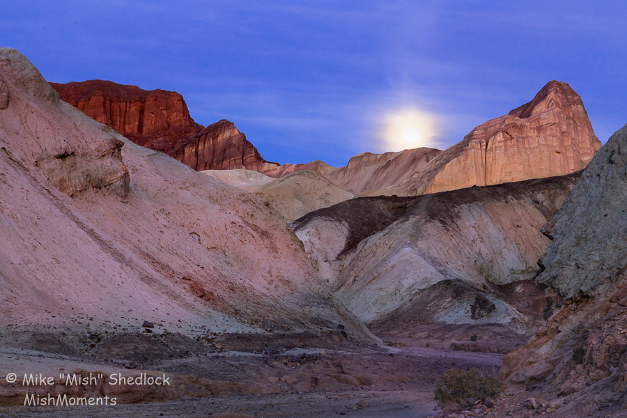
That’s the backside of Zabriskie Point on the right and the Red Cathedral on the left. The moon came up behind a layer of clouds which evened out the light.
To be precise, this was one day before the full moon. The best day to photograph a “full moon” at sunset is one day prior. At sunrise, it is one day after the full moon. The reason is ambient light. On the day of the full moon, it’s too dark.
Golden Canyon Pointed Clouds

I was hiking out of the canyon with my wife Liz and these amazing pointed clouds appeared. The above image was just before sunset. Right after sunset, those clouds turned pink.
Golden Canyon Pink Pointed Clouds Sunset

There were only a few minutes between the preceding two images. I surmise there were very strong high winds moving the clouds around.
The location was slightly different as we were walking out.
Details, Details

There are beautiful rock formations in the canyon. Do not get so distracted from the grand view that you miss these beautiful details.
The camera angle for the above image was straight down.
Note the lack of shadows. Harsh sunlight would have killed the image.
I lingered so long in the canyon after sunset taking pictures like these, that I accidentally happened to be in a perfect spot to get the moonrise image above.
Those interested in my equipment and recommendations can find it here: Mish’s Equipment List.
If you missed them, please check out my previous articles.
Share!
If you like this article, please share by email or use one of the share buttons beneath the article.
Much more coming: Click to Subscribe by Email.
Mike “Mish” Shedlock

Death Valley National Park is a phenomenal study of erosion, weather, geology, sand dunes, salt formations, and huge spring wildflower blooms on rare occasions.
This post covers Death Valley Sand Dunes, specifically the Mesquite Flat dunes.
The dunes are easily accessible, just minutes from Stovepipe Wells. They are a very popular spot. It is nearly impossible to find undisturbed ripples anywhere near the parking lot where the tallest dunes are.
The dunes area is vast. I parked a mile away to get this image. The only time the tallest dunes will be without footprints are at sunrise following a very windy evening. Even then you better be the first one up and far away from the lot, or people will be walking in from of you, messing up the shot.
Feature Image Details
Those interested in my equipment and recommendations can find it here: Mish’s Equipment List.
If you missed them, please check out my previous articles.
Share!
If you like this article, please share by email or use one of the share buttons beneath the article.
Much more coming: Click to Subscribe by Email.
Mike “Mish” Shedlock