Take an easy hike to a desert oasis loaded with palm trees.

~ Joy of Photography
Take an easy hike to a desert oasis loaded with palm trees.
Take an easy hike to a gold mine and interesting rusted cars.

The Jumbo Rocks area of Joshua Tree National Park offers a wide variety of photo opportunities.
Penguin Rock

The cholla garden in Joshua Tree is the best spot in the park to see a glorious sunrise.
Cholla Garden Sunrise

This is my second post on the color in Zion National Park this year. I’m a little delayed in editing. More coming up.
Autumn Brilliance – East Side Zion National Park

The East Side is through the main tunnels on the road to Mt. Carmel. Get out and explore.
Continue reading “Zion National Park East Side and Clear Creek: Spectacular Autumn Color”There was amazing neon color in the Zion Narrows this year. Four images. Please take a look.
Zion National Park – Narrows – Glowing Tree and Rapids

I took some milky way images this autumn. Here is a pair from Capitol Reef National Park: Pectols Pyramid in the main part of the park, and Temple of the Sun in Cathedral Valley.

Joshua Tree National Landmark is in Utah, not to be confused with Joshua Tree National Park in California. The comet comes every 80,000 years.

Great Basin National Park offers some nice high-altitude hikes. My last two posts were hikes at 10,000+ feet. The Snake Creek Overlook Trail tops out at about 8,500 feet.

Great Basin National Park in Nevada offers some nice high-altitude hikes. Bristlecone pines live at high elevations where few other trees survive.

Great Basin National Park in Nevada offers some nice high-altitude hikes. The Alpine Lakes trail is one of my favorites.


This is an image I took of Horsetail Falls in Yosemite National Park. Weather and water permitting, these falls light up in February.
Continue reading “Capturing Yosemite’s Horsetail Falls “Firefall” Magic”
This is a panoramic image that I took on January 21, 2023. It’s cropped into a 35mm 3×2 frame.
Continue reading “Tips for Dramatic Zion Photography, Kolob Canyon Sunset”
Due to the direction of the canyon walls, Bryce Canyon generally presents more opportunities at sunrise than sunset.
The Bryce Point Overlook provides a genuine Sunset opportunity. These images were taken at sunset on the same day.

Continue reading “Bryce Point is the Best Sunset Location in Bryce Canyon”
Bryce Canyon National Park in Utah is a fairyland of red, orange, and white hoodoos and spires. The rim elevation varies from 8,000 to 9,000 feet.
Rooms in the park can be difficult to obtain, so book early.

The images in this article were taken in Late July and Early August . Bryce point is an excellent sunrise location.
Continue reading “Tips for Capturing a Stunning Sunrise at Bryce Point”
Bryce Canyon National Park in Utah is a fairyland of red, orange, and white hoodoos and spires. The rim elevation varies from 8,000 to 9,000 feet.
Rooms in the park can be difficult to obtain, so book early.

The images in this article were taken in Late July and Early August. As is typically the case at Bryce Canyon, sunrise generally presents more opportunities than sunset.
Continue reading “Fairland Canyon in Bryce, an Excellent Morning Hike”
The images in this article were taken in early August. Both are panoramas taken just behind the railing at Sunrise Point and just before sunset.

Continue reading “Late Afternoon Thunderhead Clouds at Sunset, Sunrise Point in Bruce”
Winter comes early at Bryce due to the high elevation. The park is open year-round but rooms at the lodge are generally closed January and February.

Continue reading “Capturing Bryce Canyon’s Winter: A Photographer’s Guide”

Looking for spring wildflowers? The Great Smoky Mountains National Park in Tennessee is one of the best spots around. The last half of April is typically the peak time, but the timing can vary year to year.
If you miss the wildflowers, the streams are still beautiful. The images on this page were taken on the West Prong of the Little Pigeon River.
Feature Image Details
To capture scenes like these you need a long exposure. Depending on how fast the water is flowing, the range may be between 1/4 second and several seconds.
One second worked nicely for this image.
But that’s not the only requirement. One needs little to no wind, especially if there are flowers that may be moving. Finally, bright overcast or very weak sunshine though is a necessity. All of the images on this page were taken under such conditions.


Equipment List
Those interested in my equipment and recommendations can find it here: Mish’s Equipment List.
If you like this article, please share by email or use one of the share buttons beneath the article.
Much more coming: Click to Subscribe by Email.
Mike “Mish” Shedlock

Death Valley National Park is a phenomenal study of erosion, weather, geology, sand dunes, salt formations, and huge spring wildflower blooms on rare occasions.
Aguereberry Point is one of my must-see areas in the park.
The point’s elevation reaches 6,433 ft and is named for Jean Pierre “Pete” Aguereberry, a Basque miner who was born in 1874, emigrated from France in 1890, and lived at and worked the nearby Eureka Mine from 1905 to his death in 1945.
The road to the top is very rough. The park recommends a high clearance four-wheel drive vehicle. I took the trip on numerous occasions in a regular car, but you better be comfortable driving in some very unpleasant looking spots, and you better not make a mistake navigating the ruts. I saw two jeeps with flat tires, undoubtedly driving too fast or not paying attention.
The road is a bit hair-raising the first time you go to the top. After you have done it once the next time seems easy or at least easier. There is no place to turn around once you start the climb.
The feature image is from a magical trip on Christmas Eve. It was completely fogged in on the way up, with some snow falling, and I was wondering what the hell I was even doing. Towards sunset, the fog lifted.
There is no view until you reach the top.
Feature Image Details
The feature image is a single shot, not a composite or focus stack.
Here are some additional images. All the ones with fog or snow were taken on Christmas Eve.


The above image is a focus stack of three images. I was inches away from the rock. The stack is at the point closest to me, then in the middle of the rock group, then at infinity.

That image was taken at another time, one Spring.

Don’t overlook the details. There are numerous opportunities for colorful lichens on marble. These kinds of images look best in quiet light. I took that image after sunset.
Aguereberry Camp
Those not interested in taking the road up to the top can make it to the Aguereberry Camp, “Pete” Aguereberry’s homestead, and the nearby Eureka Mine, relatively easily.
The road all the way is brutal deadpan so you must drive slow and watch for rocks. There are no ruts or real danger of bottoming the car if one is reasonably careful.
This is what’s left of Aguereberry Camp.


I took that car image one morning shortly after sunrise. Anyone recognize the car?
Equipment List
Those interested in my equipment and recommendations can find it here: Mish’s Equipment List.
If you missed them, please check out my previous articles.
Share!
If you like this article, please share by email or use one of the share buttons beneath the article.
Much more coming: Click to Subscribe by Email.
Mike “Mish” Shedlock

Death Valley National Park is a phenomenal study of erosion, weather, geology, sand dunes, salt formations, and huge spring wildflower blooms on rare occasions.
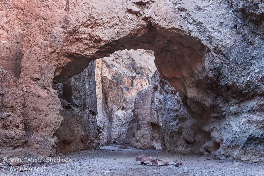
This post covers the Natural Bridge Trail, a two+ mile out-and-back round-trip. It’s an easy hike that passes under a natural bridge with views of faults, chutes, dry waterfalls and other formations.
The geologic formations and metallic-hued lava flows are out of this world.
If you only have a couple days in the park, this would not be one of my top choices to visit. But if you have a week, please take the time to explore the area.
Feature Image Details
This is a composite image of two exposures. There is one exposure for the bridge and a second exposure for the background mountains covered in snow.
I purposely did not include sky above the bridge making the shot look more like a hole in the wall rather than a natural bridge. The feature image is from behind, looking back towards the trailhead.
Here is another view, as one would see the scene hiking towards the bridge.
I have seen the above shot with wild blue, green, and yellow colors. Such images are fakes. The color on the bridge, at any time of day, is simply not that vibrant.
The best part of the trail is towards the end. The metallic-looking lava flows and marble formations do not appear to be from this world.
The trail dead ends at this point.
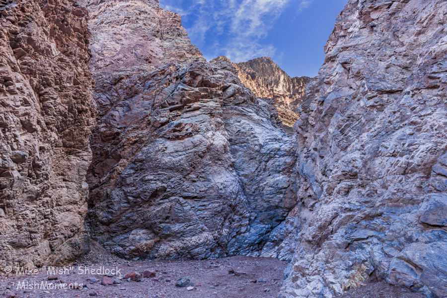
It’s a relatively easy scramble up that lava flow for a view looking back towards the trailhead. This is what it looks like.

The above image was taken with my Canon 16-35MM F4 L Lens at 16mm.
Blending
Every image in this set is a composite image. By that I mean I took multiple exposures for the brightest and darkest parts of the second and blended them manually, in Photoshop. I use the fewest number of exposures I can get away with. My preference is one.
All of these images were a blend of two exposures. On occasion, I use three.
Those interested in my equipment and recommendations can find it here: Mish’s Equipment List.
If you missed them, please check out my previous articles.
Share!
If you like this article, please share by email or use one of the share buttons beneath the article.
Much more coming: Click to Subscribe by Email.
Mike “Mish” Shedlock

Death Valley National Park is a phenomenal study of erosion, weather, geology, sand dunes, salt formations, and huge spring wildflower blooms on rare occasions.
This post covers the Golden Canyon, a three-mile point-to-point trail that is the flip side of Zabriskie Point. The elevation gain is about 613 feet. One can walk a portion of the trail and there are alternative loops instead of going point-to-point and reversing.
We did portions of this trail on numerous occasions. Whereas Zabriskie Point is a sunrise image, the Golden Canyon is primarily a sunset view.
Feature Image Details
The person in the golden garb adds a nice sense of scale. I could have easily edited him out, but I like the effect.
Golden Canyon Full Moon Rise at Sunset
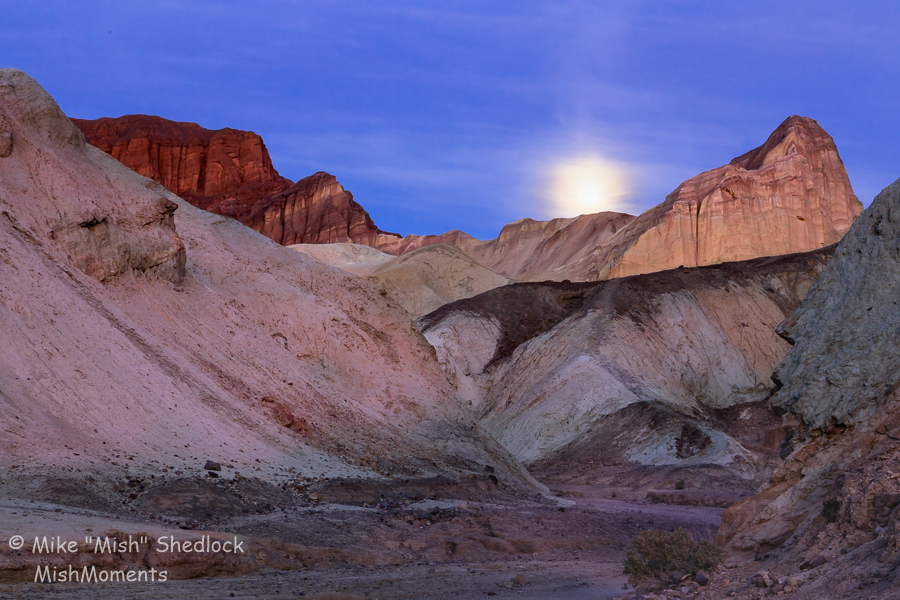
That’s the backside of Zabriskie Point on the right and the Red Cathedral on the left. The moon came up behind a layer of clouds which evened out the light.
To be precise, this was one day before the full moon. The best day to photograph a “full moon” at sunset is one day prior. At sunrise, it is one day after the full moon. The reason is ambient light. On the day of the full moon, it’s too dark.
Golden Canyon Pointed Clouds

I was hiking out of the canyon with my wife Liz and these amazing pointed clouds appeared. The above image was just before sunset. Right after sunset, those clouds turned pink.
Golden Canyon Pink Pointed Clouds Sunset

There were only a few minutes between the preceding two images. I surmise there were very strong high winds moving the clouds around.
The location was slightly different as we were walking out.
Details, Details

There are beautiful rock formations in the canyon. Do not get so distracted from the grand view that you miss these beautiful details.
The camera angle for the above image was straight down.
Note the lack of shadows. Harsh sunlight would have killed the image.
I lingered so long in the canyon after sunset taking pictures like these, that I accidentally happened to be in a perfect spot to get the moonrise image above.
Those interested in my equipment and recommendations can find it here: Mish’s Equipment List.
If you missed them, please check out my previous articles.
Share!
If you like this article, please share by email or use one of the share buttons beneath the article.
Much more coming: Click to Subscribe by Email.
Mike “Mish” Shedlock

Death Valley National Park is a phenomenal study of erosion, weather, geology, sand dunes, salt formations, and huge spring wildflower blooms on rare occasions.
This post covers the Badwater Basin Salt Flats.
Badwater is the lowest point in the US, 282 feet below sea level.
The salt flats in Badwater Basin cover nearly 200 square miles, among the largest protected salt flats in the world. Salt flats are too harsh for most plants and animals to survive, yet are quite fragile. Delicate crystals are easily crushed and the relatively thin upper crust of salt can break through to the mud layer below, leaving tire tracks and even footprints. For this reason, vehicles are prohibited off established roads in Death Valley.
Feature Image Details
Badwater, shown below is the popular stopping spot. You can explore salt polygons at Badwater, but they are trampled flat. To find good salt polygons, you need to park a mile or more away and walk out over some uneven but walkable terrain.
Badwater Sunrise

Badwater typically has a small pool of obviously undrinkable water. The white on the ground is salt. The white in the mountains is snow.
Devil’s Golf Course

Imagine trying to play golf on that surface. The salt is razor sharp. If you fall you will get cut with salt injected straight into the cut.
The above image is the Devil’s Golf Course at sunset with a Canon 14MM F2.8 L Lens. I now recommend the Canon 11-24 F4.0 L lens as a new replacement for the 14MM lens. It is the best wide angle zoom lens in the world. Period. Yes, it is very expensive. It is sharp in the corners, little or no astigmatism, or other common zoom lens flaws. At 11-24 MM it is the widest zoom lens around and it is sharp.
These images were all taken at sunrise or sunset, in the Badwater Basin area.
Those interested in my equipment and recommendations can find it here: Mish’s Equipment List.
If you missed them, please check out my previous articles.
Share!
If you like this article, please share by email or use one of the share buttons beneath the article.
Much more coming: Click to Subscribe by Email.
Mike “Mish” Shedlock

Death Valley National Park is a phenomenal study of erosion, weather, geology, sand dunes, salt formations, and huge spring wildflower blooms on rare occasions.
This post covers Death Valley Sand Dunes, specifically the Mesquite Flat dunes.
The dunes are easily accessible, just minutes from Stovepipe Wells. They are a very popular spot. It is nearly impossible to find undisturbed ripples anywhere near the parking lot where the tallest dunes are.
The dunes area is vast. I parked a mile away to get this image. The only time the tallest dunes will be without footprints are at sunrise following a very windy evening. Even then you better be the first one up and far away from the lot, or people will be walking in from of you, messing up the shot.
Feature Image Details
Those interested in my equipment and recommendations can find it here: Mish’s Equipment List.
If you missed them, please check out my previous articles.
Share!
If you like this article, please share by email or use one of the share buttons beneath the article.
Much more coming: Click to Subscribe by Email.
Mike “Mish” Shedlock

Death Valley National Park is a phenomenal study of erosion, weather, geology, sand dunes, salt formations, and huge spring wildflower blooms on rare occasions.
This post covers Artist’s Palette, one of the Death Valley must-see locations and an easy paved drive to get to the spot.
Artist’s Palette is an area on the face of the Black Mountains noted for a variety of rock colors. These colors are caused by the oxidation of different metals (iron compounds produce red, pink and yellow, decomposition of tuff-derived mica produces green, and manganese produces purple).
Called the Artist Drive Formation, the rock unit provides evidence for one of the Death Valley area’s most violently explosive volcanic periods. The Miocene-aged formation is made up of cemented gravel, playa deposits, and volcanic debris, perhaps 5,000 feet (1500 m) thick. Chemical weathering and hydrothermal alteration cause the oxidation and other chemical reactions that produce the variety of colors displayed in the Artist Drive Formation and nearby exposures of the Furnace Creek Formation.
I thought the green was copper, but it’s not.
Feature Image Details
Conventional wisdom says to get to Artist’s Palette late in the afternoon on a sunny day.
Throw that advice straight in the ashcan. I took these images mid-day on a rare cloudy day. Note the lack of strong shadows.
Diffuse light with very weak shadows is likely perfect. A professional I ran into told me he likes to go to this spot early in the morning before the sun hits it. I did not try that but it would seem to enhance the blues and greens.
Under direct sun, which I did try, the subtle pinks and light colors wash out.


Overcast days at Death Vallery are rare. If you get one, head to Artist’s Palette.
Those interested in my equipment and recommendations can find it here: Mish’s Equipment List.
Zabriskie Point
If you missed them, please check out my previous articles.
Share!
If you like this article, please share by email or use one of the share buttons beneath the article.
Much more coming: Click to Subscribe by Email.
Mike “Mish” Shedlock

Death Valley National Park is a phenomenal study of erosion, weather, geology, sand dunes, salt formations, and huge spring wildflower blooms on rare occasions.
This post covers Dante’s View at an elevation of 5,475 feet (1669 meters). It’s an easy paved road to the top, weather permitting. In the winter, the park service may close the road because of snow.
Feature Image Details
This a primarily a pre-dawn shot. As soon as the sun hits the opposite peaks there is enormous contrast. In the afternoon, you will be shooting into very harsh light, if not straight into the sun.
Even more so than Zabriskie Point, do not be late for Dante’s View. Plan to be at the top no later than 30 minutes before sunrise.
You do not need clouds for the image to work. Frequently you can catch the Belts of Venus, pink bands of light just above the horizon as I have in the feature image, but with some clouds.
Salt
That’s not snow on the ground. It’s salt. Dante’s View is a sweeping panorama of Badwater Basin, over a mile below.
Foreground Subject
One of the difficulties photographing Dante’s View is lack of a foreground subject. I took the feature image very close to the parking lot. There are trails, and I scouted them out, but the views do not improve much.
Second Pre-Dawn Image

If you arrive early, watch the light behind you. The above two shots were not taken on the same day.
Those interested in my equipment and recommendations can find it here: Mish’s Equipment List.
Zabriskie Point
If you missed it, please check out my previous article Death Valley: Zabriskie Point Sunrise, Manly Beacon.
Share!
If you like this article, please share by email or use one of the share buttons beneath the article.
Much more coming: Click to Subscribe by Email.
Mike “Mish” Shedlock

Death Valley National Park is a phenomenal study of erosion, weather, geology, sand dunes, salt formations, and huge spring wildflower blooms on rare occasions.
One of the “must see” areas is Zabriskie Point.
Manly Beacon is the high triangular-shaped outcrop on the right. Manly Beacon was named in honor of William L. Manly, who along with John Rogers, guided members of the ill-fated Forty-niners out of Death Valley during the gold rush of 1849.
Get to this spot well before sunrise. As soon as the sunrise light hits the Panamint Mountain Range on the opposite side of the valley, the shot will soon be over.
Also, you need clouds for the shot to work. If there are no clouds, try another location. The sand dunes and Dante’s View (both coming up) are better choices if the light is not dramatic.
Feature Image Details
I consider this light to be good quality and the air was clear. I would have preferred better clouds over the Panamint Range across the valley, but the clouds worked nicely as a panorama.
Manly Beacon

That is one of the images in the panorama.
By the time light hits Manly Beacon, the best images were long ago in your camera.
Do not be late for this spot, or for that matter, any spot in Death Valley. Morning light is very fleeting.
Pre-Dawn Image

In the above image, you can see the light coming up to the SouthEast (Winter). The contrast was intense. I blended two images together in Photoshop.
The advantage of staying high (at the top of the photography area) is that you can shoot in several directions. It may be better to be a bit lower for Manly Beacon but this shot vanishes.
Those interested in my equipment and recommendations can find it here: Mish’s Equipment List.
Please Share!
If you like this article, please share by email or use one of the share buttons beneath the article.
Much more coming: Click to Subscribe by Email.
Mike “Mish” Shedlock

These images are from a trip to Badlands National Park in September of 2017.
We went to the Yellow Mounds Overlook area on two occasions. After Pinnacles, it is my next favorite overlook. There are opportunities on both sides of the road if you wander around a bit.
Feature Image Details
This image and two that follow are stacked images. That means I took multiple images, each focused on a different spot. I used Lightroom to adjust the exposures and color, the same for each image in the stack. Then I manually blended them in Photoshop using layer masks.
With four images, I blend two images. Then blend the next. Then the next. I find starting with the foreground the easiest.
Here are more Yellow Mounds images.


The final image above was not focus stacked. It was taken at 28mm with a Canon 24-105MM F4 L Lens
There was little need to stack. Everything was in focus because this was a distant shot. When you are very close to the subject and want every part of the image, you need to focus stack.
Big Badlands Overlook

Big Badlands Overlook is an excellent location at sunrise. At sunrise, it’s my favorite overlook.

I went to this overlook five times at sunrise and had good clouds only once. The best light was before sunrise. Compare the above two images. I prefer the first. It was 10 minutes or so before sunrise.
Big Badlands Panorama Stitch

That’s a crop from an even wider sequence of five images stitched together. I took that sequence one morning when there was decent light but no clouds.
Lightroom usually does a good job of stitching automatically as was the case here. I use Photoshop merge on occasion, but Lightroom is easier to work with.
Equipment
Those interested in my equipment and recommendations can find it here: Mish’s Equipment List.
Additional Badlands Articles
Please Share!
If you like this article, please share by email or use one of the share buttons beneath the article.
I will wrap up the Badlands in my next article. It has an image of me reflected in a Meadowlark’s eye. Stay tuned!
Much more coming: Click to Subscribe by Email.
Mike “Mish” Shedlock

These images are from a trip to Badlands National Park in September of 2017. As is typically the case, sunrise and sunset images provide the best light, but there are exceptions.
Feature Image Details
The feature image and the next three images that follow were taken minutes before sunset.
There are at least six cars in the parking lot that I can make out in the feature images. At least another six left within ten minutes of these images.
It was raining hard the sky was 99.5% overcast. No one else got out of their car.


If one was not down at the canyon edge, there was no shot except for the parking lot and road.
The image immediately above was taken right at sunset. You can see the sliver of a hole the sun hit to create the rainbow. When I got out of the car, the only hole was way to the right. The gap lengthened horizontally just as I arrived at the above location. I did not expect this to happen, nor did anyone else, but I took a chance, and I got wet.
Just as the sun hit the sliver of a hole, it stopped raining on me but it did keep raining in the distance. That’s what it takes to make a rainbow. You do not see rainbows looking towards the sun. The apex of the rainbow is 180 degrees from the sun.
Decision Time
I walked down to the location with a Canon 16-35MM F4 L Lens on my camera. It was not wide enough to catch that complete rainbow. When the sun hit the hold, I did not know if I had 10 seconds, 30 seconds, or two minutes, but I knew I did not have longer than that.
I wanted that full rainbow image badly, so I took a chance and changed lenses. Taking an extra 15 seconds to change lenses in fleeting light is a huge gamble but it paid off. I grabbed two quick shots, changed lenses back again, and rushed over to the ledge where I took the second rainbow image.
Note the foreground. Imagine the image without the railing. Extreme wide angle lenses must have a strong foreground. I used the railing because it was all that was available on the left side of the frame. I hopped over the railing to take this image.
Seconds later the light faded. I estimate I had about 90 seconds to photograph the rainbow. Had one been in their car, it would have taken most of that time to get down to the location where I was.
I had more time for the third image, as in several minutes. The rainbow was gone but the clouds in the West started glowing. It’s hard to tell from these images, but it really was 99.5% socked-in gray. That little hole provided the magic.
The third image is an exposure composite, one of the foreground, the other of the sky.
More Badlands Images
This is my second in a series on the Badlands. Please also check out Badlands National Park – Castle Trail and Notch Trail Images.
Equipment
Those interested in my equipment and recommendations can find it here: Mish’s Equipment List.
Please Share!
If you like this article, please share by email or use one of the share buttons beneath the article.
Much more coming: Click to Subscribe by Email.
Mike “Mish” Shedlock